
At times I enjoy reflecting on past adventures and today is such a day. One of my most memorable backpacking trips was on Haida Gwaii (previously known as the Queen Charlotte Islands), a chain of islands located off the coast of British Columbia just south of the Alaska panhandle. Haida Gwaii is not an easy place to hike and it's even harder to backpack. The windward (western) side of the islands is very rainy (slippery) and the landscape is steep. But there is an interesting trail located on the leeward (sheltered eastern) side of the largest island in the archipelago, Graham Island. That's where I did an interesting backpacking trip about a decade ago.

(Sunset at Misty Meadows Beach, site of our first night's camp)
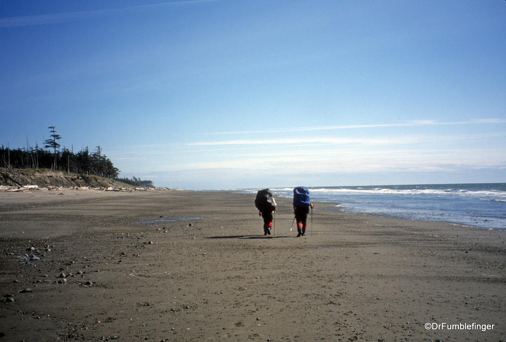
While it's called a “trail”, it's mostly a beach walk in Naikoon Provincial Park. Formal trails lead to and from the beach walk at either end, but the 89 kilometers in between these bookends lacks a developed trail. The route is easy to follow as you're walking by the sea and is fairly flat, but it's not an easy hike. The sand can be soft, which really tires and slows you down, and in places it's muddy. There are many rocky ledges which are slippery in the rain or when the tide goes out. Also, there's a forest of washed up dead trees on the beach at times making it difficult to move along.
As you walk along the beach you'll need to ford the mouths of several rivers, so you need to be aware of the tidal charts (obviously you ford them at low tide, unless you want to swim across with your full backpack at high tide). You might have to wait for hours by a river for the right chance to cross it.

(The beginning of the trek, hiking the Tlell River trail to the beach)
What kind of scenery will you see on your 89 km walk? There are beautiful forests, sandy hills, endless beaches, and lots of uprooted trees. And of course there's the sea, with waves lapping the beach and a wonderful fresh breeze. I've never seen more bald eagles anywhere in my life, and I'd say on an average day we encountered at least 100 bald eagles on East Beach Trail -- they were everywhere and were magnificent!


One of the best features of the hike is its solitude. You'll meet very few people on East Beach Trail, often going days without encountering anyone. Those humans you'll see are generally on a day hike at either end of the trail, especially at the southern Tlell end where you'll find the dramatic shipwreck of the Pesuta, a log barge that ran aground in 1928. This is where we began our hike.


(DrFumblefinger at the Pesuta shipwreck)
After days of walking and camping on and near the beach, we ended at Rose Spit, an ecologic reserve at the northern end of the island. It's a (relatively) newly deposited thumb of land that contains grasslands and further along, is just composed of rocks and sands. It made for an interesting day hike and you can see photos of it below.

(My great campsite on a soft sandy beach, with the best view anywhere!)

At the north end of the trail, we returned to civilization by cutting through the woods on the Cape Fife trail. This is an old settler's road (10 km long) with the remains of a few old cabins. Cape Fife is the muddiest trail I've ever walked -- I was often up to my knees in mud and the going was very tough.

(Cape Fife Trail)
The East Beach Trail is a full wilderness experience. You need to be prepared for remote and extreme conditions. The weather can be sunny and warm one minute, quickly becoming windy, rainy and cold. There are no services, no cell phone reception, no running water, no toilets (except at trailheads) along the multi day route. There are no hotels or cabins, although a few wooden shelters are found along the route, handy for cooking and staying dry if it is raining. Black bears are plentiful on the island, so use proper precautions.
More scenes of the East Beach Trail hike:
......Eagle creek campsite, at the foot of sandy cliffs....


...and with lots of driftwood.....


......fjording a river....

...the Oneida River shelter.....

At the north end of the trail is Rose Spit, a peninsula and ecologic preserve that contains grassland at its most southern end.....


....and at the far end of Rose Spit, the grass disappears and you have a sandy beach.....

.....and Agate Beach at the north end of the island, our last night camping, where we enjoyed a beautiful sunset! It took us a week get to and from the island by ferry from Prince Rupert and to complete the trek. But it was a most memorable experience.


Comments (2)